Whatever Strikes my Fancy.
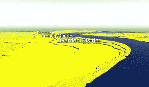
This is an animation I just made of the flood happening in New Orleans tonight. With the levee break water levels are going to rise overnight to about one metre above sea level. The highest ground in the city is only one metre above sea level. Most of the city excluding downtown and the historic areas are four or five metres below sea level. Downtown, the French Quarter and the Garden District are on "high ground" that is anywhere from sea level to two metres below sea level. The animation pauses at the three metres below sea level water level, which is roughly where the water was at just after the storm passed.
Of course this is just based on surface contours and there is no accounting for the fact that any buildings tall enough will be sticking out of the flood water. When the water is done rising tonight the water will be up to the iron balconies of the French Quarter. I haven't shown the West Bank flooded as it is unaffected by the breeched levee There is, of course, flooding from the rain water, but the reports are that most of Algiers is "dry". |
Oringinal post: http://mbarrick.livejournal.com/646250.html